
Editor’s Note: Parts of the Chicago area are under an “enhanced” risk of severe weather Tuesday evening, which ranks as level three of five. Early Tuesday morning, a first round of non-severe storms was moving through the area. Use our radar below to track the rain near you.
Parts of the Chicago area Tuesday woke up to rain, rumbles of thunder, lightning and even small hail as a line of thunderstorms passed through, with possible impacts to the morning commute.
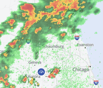
As of 6 a.m., Live Doppler 5 Radar showed a line of storms stretching through Mendota, DeKalb, Algonquin, Marengo, Woodstock and Waukegan, with heavy rain stretching into Kenosha and further north.
The rain was already impacting early morning suburban commutes, NBC 5 traffic reporter Kye Martin said, especially on tollways.
The storms were also impacting air travel. According to the Federal Aviation Administration, a ground delay was in effect at O’Hare Airport, expected to last through at least 8 p.m. At Midway, a ground stop was in effect until 8 a.m.
The round Tuesday morning was not expected to turn severe, NBC 5 Storm Team Meteorologist Alicia Roman said, as they moved from west to east.
By about 9 a.m., storms will move out of Illinois and into northwest Indiana, Roman said, leaving behind several hours of dry time.
About 5 p.m., a second round of showers and storms are likely to develop, Roman said, with “all weather hazards at play.”