
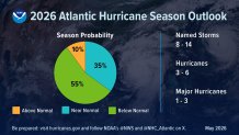
The 2026 Atlantic Hurricane season forecast is out, and the expectation is a below-normal season, according to the National Oceanic and Atmospheric Administration. But there is an important takeaway for this year’s season, and beyond.
With eight to 14 named storms, three to six hurricanes, and one to three major hurricanes, the numbers may be lower-than-normal, but they could be more dangerous.
The strength of the developing El Niño will be a big factor to the amount of storms we may see. Warmer waters in the equatorial Pacific Ocean manipulate the upper level wind patterns. In short, a warmer Pacific Ocean often creates faster winds aloft (wind shear) over the Atlantic where hurricanes form. Tropical systems develop much easier when the upper winds are light.
On the other side, a warmer Pacific Ocean means an above-normal season is more likely in the Eastern Pacific basin. NOAA’s outlook predicts nine to 14 hurricanes, five to nine of them major hurricanes in the Eastern North Pacific basin.
There is an important takeaway for this year’s hurricane season, and beyond.
Significantly warmer ocean temperatures due to climate change are making hurricane forecasting more difficult, and more important than ever. Hurricanes are undergoing “rapid intensification” at a higher rate.
What is “rapid intensification”?
It’s defined as an increase of 35 mph winds in a 24-hour period. Since 2020 the Atlantic averages six to seven storms that rapidly intensify.Some of those, like Hurricanes Erin (2025), Humberto (2025), Melissa (2025), and Milton (2024) had a wind increase of 85 to 95 mph in a 24-hour period – nearly triple the rate of the RI definition. That means a tropical storm could become a Category 5 hurricane in one day.
So we may see fewer storms in the Atlantic, but the storms that do form are getting stronger, and at a quicker rate.
NOAA Forecasting Changes
As forecasts are becoming more accurate, the National Hurricane Center (NHC) forecast cones in 2026 will be roughly 4-8% smaller than last year.
The cones are also going to be created based off a series elliptical shapes rather than circles in the placement of tropical systems in computer model projections.
The NHC will also be including inland tropical storm and hurricane alerts in the forecast cones this year, rather than just coastal areas.
The NHC will also have the ability to issue advisories up to 72 hours before a storm even forms; allowing more time to prepare if a storm were to rapidly intensify.